
Google unveiled Groundsource today, an AI system that converts millions of global news reports into structured data for predicting natural disasters. The technology, powered by Google’s Gemini language model, has already compiled 2.6 million historical flood events and enabled 24-hour advance flood warnings through Google’s Flood Hub platform.
The system processes news articles across 80 languages, using Google’s Read Aloud user-agent to extract text before standardizing content into English through the Cloud Translation API, according to the Google Research Blog. The translated information then feeds into the Gemini model, which identifies crucial details about flood events including location, timing, and severity.
Google Maps integration converts descriptive reports into geospatially defined data points, transforming unstructured information from government reports and local bulletins into actionable intelligence. This methodology has produced an open-access dataset spanning 150 countries from 2000 to present, Google said in its announcement.
Performance Exceeds Traditional Systems
Manual reviews revealed that 60% of extracted events proved accurate in both location and timing, while 82% were deemed accurate enough for practical real-world analysis, such as correctly identifying administrative districts or pinpointing event timing within one day of peak occurrence, according to Google’s research findings.
When benchmarked against the Global Disaster Alert and Coordination System (GDACS), a joint UN and European Commission initiative, Groundsource captured between 85% and 100% of severe flood events recorded from 2020 to 2026. The system also identified numerous smaller, localized flash floods typically missed by satellite-based monitoring, the company reported.
The historical dataset now powers a new forecasting model for urban flash floods, delivering predictions up to 24 hours in advance through Google’s Flood Hub platform globally.
Expansion Beyond Floods
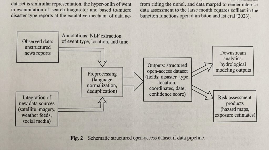
Google plans to apply the Groundsource framework to other natural disasters where historical data remains sparse, including droughts, landslides, heat waves, and avalanches, according to the research team. The company is actively refining the model to expand coverage to rural areas while integrating new data sources to improve accuracy.
The methodology addresses critical gaps in disaster preparedness by enabling sophisticated hydrological modeling and risk assessment for researchers and emergency response agencies worldwide. By systematically converting unstructured news reports into structured, open-access datasets, Groundsource positions itself as a foundational tool for building community resilience against natural hazards.
Sources
- blog.google
- research.google/blog